
Tabula Anemographica seu Pyxis Nautica Ventorum Nomina Sex Linguis Repraesentans (1650) by Jan Jansson or Johannes Janssonius (1588–1664)

Nova Totius Terrarum Orbis Tabula (1684) by A. J. Bormeester

Perigrinatie ofte Veertich-Iarige Reyse der Kinderen Israels (1702) by N. Visscher and D. Stoopendaal
_-_Geographicus_-_Paris-turgot-1909.jpg)
Plan de Paris, the c. 1900 Taride edition of Louis Bretez and Michel-Etienne Turgot's monumental 1739 map of Paris.
_-_Geographicus_-_Catalogne-ratelband-1747.jpg)
Principaute de Catalogne et Partie du Rous sillon Echelle de Lieux, a stunning map of Catalonia, Spain first drawn by Daniel de la Feuille in 1706

Eiland Ormus, of Jerun, engraved by Jacob Van der Schley under the supervision of J. Bellin for the c. 1750 edition of Provost's L`Histoire Generale des Voyages

Plan de la Forteresse de Coylan, a rare 1756 map of the fort of Kollam, Kerala, on India’s Malabar Coast by French cartographer N. Bellin
_-_Geographicus_-_Edinburgh-craig-1768.jpg)
Plan of the New Streets and Squares intended for the city of Edinburgh, drafted for the city planning committee in 1768 by James Craig

Sphere de Ptolomee, a beautiful example of Rigobert Bonne's curious decorative chart of the Spheres (1775)

Essay on the Battle of Plataea for the Travels of Anacharsis, 1784 color map showing the Battle of Plataea by Barbie du Bocage

A General Map of the World, or Terraqueouis Globe with all the New Discoveries and Marginal Delineations, Containing the Most Interesting Particulars in the Solar, Starry and Mundane System; an absolutely stunning and monumental double hemisphere wall map of the world by Samuel Dunn dating to 1794

New and Improved View of the Comparative Heights, of the Principal Mountains and Lengths of the Principal Rivers in the World. A groundbreaking convention establishing map of extreme scarcity, this is William Darton and W. R. Gardner’s 1823 comparative mountains and rivers of the world chart.

Table of the Comparative Heights of the Principal Mountains in the World; Finley’s attractive c. 1826 map of the comparative heights of the principal mountains of the world.

Physical Geography. Humboldt’s Distribution of Plants in Equinoctial America, According to Elevation Above the Level of the Sea (1839)
_-_Geographicus_-_USAwall-mitchell-1844.jpg)
Mitchell’s National Map of the American Republic or The United States of North America. Together with Maps of the Vicinities of Thirty-Two Principal Cities and Towns in the Union (1845)
_-_Geographicus_-_NYC33Miles-colton-1879.jpg)
Map Of The Country Thirty Three Miles Around The City Of New York (1879), by Joseph Hutchins Colton

Afrique; a stunning c. 1847 map of Africa by French cartographer Victor Levasseur

Shintei - Chikyu Bankoku Hozu (Square Map of all the Countries on the Globe); a very interesting 1853 (Kaei 6) Japanese world map by Suido Nakajima.

Colton's Railroad & Township Map of the Western States compiled from the United States Surveys (1854)

The Constellations (December November October); this rare hand coloured map of the stars was engraved by W. G. Evans of New York for Burritt’s 1856 edition of the Atlas to Illustrate the Geography of the Heavens.
Operation Doorstep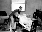 | The Spirit Photographs of William Hope | The Maps of Piri Reis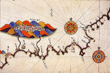 | Dr Julius Neubronner's Miniature Pigeon Camera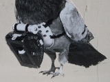 |
Art in Art | Huexotzinco Codex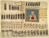 | Sessions for the Blind at Sunderland Museum | Eugène von Guérard's Australian Landscapes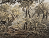 |
Landscape and Marine Views of Norway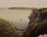 | The Mechanism of Human Physiognomy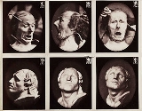 | Space Colony Art from the 1970s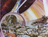 | Men in Wigs |
De humana physiognomonia libri IIII (1586)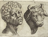 | Field Columbian Museum | Maps from Geographicus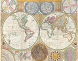 | Arnoldus Montanus' New and Unknown World (1671) |